The Rupin Pass Trek, which connects Uttarakhand and Himachal Pradesh and culminates at 15,250 feet, is a 35-55 kilometer (distance varies by starting point- Dhaula, Jiskun, Gosangu) gut-punch through the Himalayas. It's a beast—pine forests, dubious river crossings, and views that will make you forget your blisters—and I've trudged through it twice. But if you're not prepared, it can bite. Imagine slick rocks, headaches from altitude, or being caught off guard by a storm. Here are the must-see stops, along with advice on how to stay motivated and upright. And it is highly recommended to hire a local guide or an experienced agency for the Rupin Pass trek, as it will help you to ease your struggle and ensure a smooth and safe trek.
Why Rupin Pass Is Fantastic
High passes, lush valleys, and seemingly lost villages abound on this trail. Following the Rupin River, it curves like sudden fog and icy gullies.
- Why It's Epic: Wild diversity, such as 1,000-foot waterfalls and meadows, and the Kinnauri culture.
- What Could Go Wrong: fainting at 15,000 feet, slick paths, or leeches in July.
- Hack It: For up-to-date trekker posts, scan social media; real-time intelligence is superior to guidebooks.
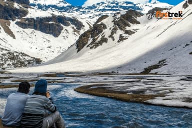
Line of Start: Dhaula (5,100–5,500 ft)
After a rough eight-hour drive from Dehradun, you will arrive at Dhaula, a dusty dot in Uttarakhand. Don't expect much because it's only a jumping-off point.
What You See: A peaceful village, simple lodges, and the thundering of the Rupin River.
Avoid Making a Mistake:
- On the first rocky crossing, test your boots.
- With your outfitter (Indiahikes is reliable), lock in permits.
- Rain turns the start into a mudfest, so check the weather.
Sewa (8,000 feet) is the first major stop
Trek 8–10 km (4-5 hours) through pine and oak to Sewa, a Kinnauri village with apple trees and houses with sloping roofs. Locals drinking chai and Kinner Kailash peering through the clouds create a certain vibe.
What's cool:
- Chatting over tea with shepherds is cool.
- First real mountain views.
Stay Alert:
- Leeches are awful, so trekkers in the monsoon season put salt on their socks and wear gaiters.
- To deal with the altitude bump, swallow water.
- Locals know the dirt, so ask them about the next leg.
Ascending: Jakha (10,000 feet)
Reasons to Stop:
- Views of the Killer Valley at sunset.
- Only the whistling of the wind and cowbells.
Be cautious:
- Ankles dislike surprises, so tread lightly on narrow paths.
- The nights are cold, so bring a fleece.
- For a brief smile, spot a monal bird.
Forest Pitstop: Udaknal (10,000 Feet)
Travel 4 km from Jakha to Udaknal, a camp surrounded by fir trees that resembles a hug from the natural world. Before the trail becomes gnarly, it's calm.
The Good Stuff:
- The sun is cutting through towering trees.
- If you're lucky, pheasant calls.
Smart Moves:
- Stay on course because fog quickly obscures trails.
- Bring extra water because the streams are not reliable.
- Verify your equipment—zippers are useless.
Meadow Break: 11,150-foot Saruwas Thatch
Saruwas Thatch, a meadow in the Rupin gorge, is reached after a 7-kilometer hike from Udaknal. It's perfect for Instagram because of the June wildflowers and grazing sheep.
The Reason It's Awesome:
- The ideal location for a tent under the stars.
- The roar of the river keeps it authentic.
Avoid Blowing It:
- Without snow, cross rivers move slowly—currents are dangerous.
- Before the wind gets stronger, set up camp.
- For nighttime trips to the bathroom, a headlamp is your friend.
Nightingale Camp is high ground (12,000 feet)
Nightingale Camp opens into alpine turf five kilometers from Saruwas Thatch. It's beautiful but stark.
Highlights:
- expansive views of the valley at dawn.
- The air is crisp but thin.
Remain Firm:
- Do you feel dizzy? Back off if it's bad; that's altitude.
- Stay on paths; fog can create a maze.
- The temperature drops at night, so dress in layers.
Lower and Upper Camps' Waterfall Vibes
The trail ends at Upper Waterfall Camp (13,100 feet, 3 km up) and Lower Waterfall Camp (11,800 feet, 6 km from Nightingale).
Lower Waterfall:
- Your face is sprayed by a misty cascade.
- The roar of the river energizes you.
Upper Waterfall:
- An incredible 1,000-foot drop with three tiers.
- Snow peaks are the main attraction.
Keep It Tight:
- On slippery rocks, poles come in handy.
- Thin air is a thief, so move slowly.
- In May, gloves for icy grips.
Rupin Pass (15,250 feet) is the Beast
Rupin Pass is reached after a 5–6 km predawn slog from Upper Waterfall. The gully is a nightmare in 70 degrees with snow and scree.
Why It's Valuable:
- 360-degree views of Kailash and Kinnaur.
- You'll feel fantastic.
Avoid Death:
- Start at 3 a.m. to avoid slush and crowds.
- Rocks and slides are real, so bring an ice axe and helmet.
- Having trouble breathing? Use an oxygen cylinder and an electrolyte in water.
Running Downhill: Ronti Gad to Sangla
Cruise to Sangla Valley after dropping 7 km from the pass to Ronti Gad, which is 13,100 feet above sea level. The end is made easier by apple trees and meadows.
Last Goodies:
- Baspa River gleams.
- Sangla's post-trek chai markets.
Conclusion:
- Prepare your knees for the rough descent.
- Sangla transportation is available, so reserve it in advance.
- To show off your victory, take a team photo.
Final Remarks
- Get Ready: Prepare by engaging in lengthy, strenuous hikes. Make a reservation with Trek. Trek traffic varies seasonally; better to state “peak seasons (May–June, Sept–Oct) see heavy crowds.
- Stay Informed: The most recent trail dirt is revealed by weather apps.
Although Rupin Pass is difficult, the cliffs of Jakha, the waterfalls, and the pass make it a memorable experience. Prepare thoroughly, remain alert, and absorb it. Happy travels!